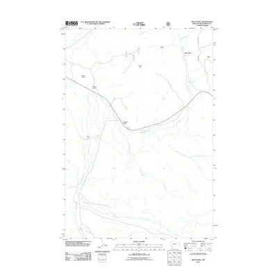
2011 Map of Butch Hill
USGS Topo · Published 2011About this map
Gloss Place and Hairpin Ranch anchor this corner of Beaverhead County, Montana, where a complex network of seasonal and perennial watercourses flows through the high-elevation landscape. The topography is defined by prominent rises such as Butch Hill and Inabnit Butte, which look down upon a drainage system that includes Bull Creek, Cow Cabin Creek, and Lancey Creek. The presence of Prines Cabin near the northern boundary suggests the area's legacy of ranching and remote habitation.
Find a feature on this map
20 named features on this map. Tap any name to fly to it.
Don’t see what you’re looking for? This feature index may not catch every label — zoom into the map to look around manually.
Map Details
Editions of this 2011 Butch Hill Map
This is the sole edition of this map. No revisions or reprints were ever made.
Other maps of this area

1955 · Dillon
USGS Topo · 1:250,000

1957 · Dillon
USGS Topo · 1:250,000

1958 · Dillon
USGS Topo · 1:250,000

1959 · Polaris
USGS Topo · 1:62,500

1959 · Grant
USGS Topo · 1:62,500

1962 · Dillon
USGS Topo · 1:250,000

1965 · Dillon
USGS Topo · 1:250,000
1978 · Jackson
USGS Topo · 1:24,000

1978 · Butch Hill
USGS Topo · 1:24,000
1978 · Jackson Hill
USGS Topo · 1:24,000