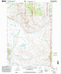
1997 Map of Butch Hill
USGS Topo · Published 2002About this map
Butch Hill stands as a prominent high point in this corner of the Beaverhead National Forest, where the topography transitions from the timbered slopes of the Wisdom Ranger District and Dillon Ranger District into the broad, water-managed valleys below. The landscape is defined by an intricate network of irrigation systems necessary for high-country ranching, including the Main Jackson Ditch, Tebo Ditch No 13, and the Upper Fox Creek Ditch. These man-made watercourses follow the contours of the land, diverting flow from natural drainages like Nellie Creek and Harrison Creek. Traces of human habitation and working life are visible at sites like Prines Cabin, Hairpin Ranch, and the Gloss Place. The map captures a moment in the late twentieth century when traditional land use—ranching, forestry, and water management—remained the primary drivers of the local geography.
Find a feature on this map
38 named features on this map. Tap any name to fly to it.
Don’t see what you’re looking for? This feature index may not catch every label — zoom into the map to look around manually.
Map Details
Editions of this 1997 Butch Hill Map
This is the sole edition of this map. No revisions or reprints were ever made.
Other maps of this area

1955 · Dillon
USGS Topo · 1:250,000

1957 · Dillon
USGS Topo · 1:250,000

1958 · Dillon
USGS Topo · 1:250,000

1959 · Polaris
USGS Topo · 1:62,500

1959 · Grant
USGS Topo · 1:62,500

1962 · Dillon
USGS Topo · 1:250,000

1965 · Dillon
USGS Topo · 1:250,000
1978 · Jackson
USGS Topo · 1:24,000

1978 · Butch Hill
USGS Topo · 1:24,000
1978 · Jackson Hill
USGS Topo · 1:24,000