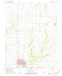
1961 Map of Butler
USGS Topo · Published 1977About this map
Butler serves as the focal point of this Bates County survey, showing the community just as the mid-century era was reshaping the local landscape. The town's grid is dense with civic and social landmarks, including the Courthouse, City Hall, and the local High Sch. The Missouri Pacific railroad runs north-south through the region, connecting the seat of Mount Pleasant township to the smaller northern settlement of Passaic.
Find a feature on this map
33 named features on this map. Tap any name to fly to it.
Don’t see what you’re looking for? This feature index may not catch every label — zoom into the map to look around manually.
Map Details
Editions of this 1961 Butler Map
2 editions found
Other maps of this area

1887 · Butler
USGS Topo · 1:125,000

1894 · Butler
USGS Topo · 1:125,000

1937 · New Home
USGS Topo · 1:24,000

1947 · Lawrence
USGS Topo · 1:250,000

1950 · Lawrence
USGS Topo · 1:250,000

1956 · Lawrence
USGS Topo · 1:250,000

1961 · Lawrence
USGS Topo · 1:250,000
1961 · Pleasant Gap
USGS Topo · 1:24,000
1961 · Main City
USGS Topo · 1:24,000
1961 · Butler
USGS Topo · 1:24,000