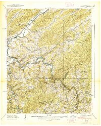
1938 Map of Butler
USGS Topo · Published 1938About this map
Butler stands as a central settlement along the Roan Creek and Watauga River during the late 1930s, showing a landscape defined by small mountain communities and rural educational hubs. The presence of Watauga Academy and various specialized schools like the Sink Valley Sch and Frog Pond Sch suggests a socially organized backcountry. The confluence of the Elk River and Watauga River is a focal point of activity, marked by crossings like the Upper Flume Bridge and the Dugger Bridge. Local family histories are etched into the terrain through features such as the Grindstaff Cem and settlements like Cowanstown and Buntontown. This Tennessee Valley Authority survey captures the intricate drainage patterns of Little Dry Run and Leaf Creek before regional water management projects permanently altered these valley floors.
Find a feature on this map
96 named features on this map. Tap any name to fly to it.
Don’t see what you’re looking for? This feature index may not catch every label — zoom into the map to look around manually.
Map Details
Editions of this 1938 Butler Map
3 editions found
Other maps of this area

1891 · Roan Mountain
USGS Topo · 1:125,000

1893 · Cranberry
USGS Topo · 1:125,000

1894 · Roan Mountain
USGS Topo · 1:125,000

1895 · Cranberry
USGS Topo · 1:125,000

1899 · Cranberry
USGS Topo · 1:125,000

1902 · Cranberry
USGS Topo · 1:125,000

1904 · Roan Mountain
USGS Topo · 1:125,000

1934 · Valle Crucis
USGS Topo · 1:24,000

1934 · White Rocks Mtn
USGS Topo · 1:24,000

1934 · Elk Park
USGS Topo · 1:24,000