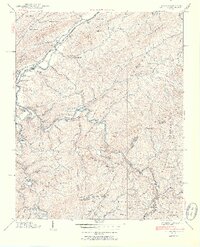
1938 Map of Butler
USGS Topo · Published 1954About this map
Butler stands at the confluence of Roan Creek and the Watauga River in this pre-reservoir survey conducted by the Tennessee Valley Authority. The map documents a landscape of mountain hollows and river bottomlands before the creation of Watauga Lake, featuring the original town site and the Watauga Academy. The area is densely settled with local institutions like Bradley Sch, Frog Pond Sch, and Mount Gilead church. Evidence of the valley's transport infrastructure is preserved through the route of the Southern RR and the Dugger Bridge. Numerous family-named landmarks such as Grindstaff Mountain and Grindstaff Cem provide essential data for genealogists tracing families in the northeastern corner of the state near the North Carolina border. The terrain transitions from the river levels to the high reaches of Pisgah Mountain and the Watauga National Forest.
Find a feature on this map
88 named features on this map. Tap any name to fly to it.
Don’t see what you’re looking for? This feature index may not catch every label — zoom into the map to look around manually.
Map Details
Editions of this 1938 Butler Map
3 editions found
Other maps of this area

1891 · Roan Mountain
USGS Topo · 1:125,000

1893 · Cranberry
USGS Topo · 1:125,000

1894 · Roan Mountain
USGS Topo · 1:125,000

1895 · Cranberry
USGS Topo · 1:125,000

1899 · Cranberry
USGS Topo · 1:125,000

1902 · Cranberry
USGS Topo · 1:125,000

1904 · Roan Mountain
USGS Topo · 1:125,000

1934 · Valle Crucis
USGS Topo · 1:24,000

1934 · White Rocks Mtn
USGS Topo · 1:24,000

1934 · Elk Park
USGS Topo · 1:24,000