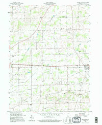
1992 Map of Butler West
USGS Topo · Published 1995About this map
Taylor Corner and Franklin Center anchor the rural landscape of northeastern Indiana in this detailed survey, where the township boundaries of Franklin, Wilmington, Grant, and Union meet. The terrain is defined by an extensive drainage network, including the Matson Ditch and Donnell Ditch, which support the agricultural character of the region. Transportation history is etched into the land via the Grand Army of the Republic Highway and several stretches of the Old Railroad Grade, tracing former transit corridors through the countryside near Butler. Genealogists will find significant value in the documentation of local landmarks such as Norris Chapel and its cemetery, alongside scattered burial sites like Lutz Cem and Rude Cem. The small settlement of Moore sits at a rural crossroads, illustrating the persistence of established community names within the modern township system.
Find a feature on this map
29 named features on this map. Tap any name to fly to it.
Don’t see what you’re looking for? This feature index may not catch every label — zoom into the map to look around manually.
Map Details
Editions of this 1992 Butler West Map
This is the sole edition of this map. No revisions or reprints were ever made.
Other maps of this area

1939 · Hamilton
USGS Topo · 1:24,000

1940 · Metz
USGS Topo · 1:24,000

1942 · Ashley
USGS Topo · 1:24,000

1948 · Hamilton
USGS Topo · 1:24,000

1953 · Fort Wayne
USGS Topo · 1:250,000

1956 · Fort Wayne
USGS Topo · 1:250,000

1957 · Auburn
USGS Topo · 1:24,000

1957 · Waterloo
USGS Topo · 1:24,000

1958 · Hicksville
USGS Topo · 1:24,000

1958 · Butler West
USGS Topo · 1:24,000