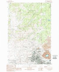
1989 Map of Butte North
USGS Topo · Published 1989About this map
The massive Berkeley Pit and the dense urban grid of Butte dominate this late-1980s landscape, illustrating a community built entirely around industrial extraction. North of the main city, the hilltop settlements of Walkerville and Centerville appear amidst a concentration of historic workings, including the Granite Mountain Mine, Badger State Mine, and Mountain Con Mine. These sites sit at the edge of the Deerlodge National Forest, where the terrain rises sharply toward the Continental Divide in the northeastern corner.
Find a feature on this map
64 named features on this map. Tap any name to fly to it.
Don’t see what you’re looking for? This feature index may not catch every label — zoom into the map to look around manually.
Map Details
Editions of this 1989 Butte North Map
This is the sole edition of this map. No revisions or reprints were ever made.
Other maps of this area

1889 · Helena
USGS Topo · 1:250,000

1893 · Helena
USGS Topo · 1:250,000

1893 · Dillon
USGS Topo · 1:250,000

1899 · Boulder
USGS Topo · 1:125,000

1899 · Helena
USGS Topo · 1:250,000

1903 · Helena
USGS Topo · 1:250,000

1947 · Butte
USGS Topo · 1:250,000

1954 · Elk Park
USGS Topo · 1:62,500

1955 · Dillon
USGS Topo · 1:250,000

1957 · Dillon
USGS Topo · 1:250,000