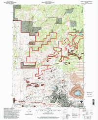
1996 Map of Butte North
USGS Topo · Published 1998About this map
Berkeley Pit and its adjacent mining operations dominate the southeastern landscape of this Montana quadrangle, where the industrial legacy of the Copper King era is etched into the earth. The dense grid of Butte gives way to specialized worker communities like Walkerville and Centerville, situated among a high concentration of named shafts such as the Granite Mountain Mine and Lexington Mine. This proximity between residential areas and massive extractive operations highlights the unique urban-industrial character of the Summit Valley district. North of the city, the terrain transitions into the Deerlodge National Forest, where the Continental Divide winds along the high ridges. These mountains are drained by numerous gulches, including Columbia Gulch and Harrison Creek, which flow toward the developing valley floor. Cultural and educational landmarks like Montana Tech of the University of Montana and the Museum anchor the western edge of the city, reflecting the community's evolution into a regional center for technology and history.
Find a feature on this map
57 named features on this map. Tap any name to fly to it.
Don’t see what you’re looking for? This feature index may not catch every label — zoom into the map to look around manually.
Map Details
Editions of this 1996 Butte North Map
This is the sole edition of this map. No revisions or reprints were ever made.
Other maps of this area

1889 · Helena
USGS Topo · 1:250,000

1893 · Helena
USGS Topo · 1:250,000

1893 · Dillon
USGS Topo · 1:250,000

1899 · Boulder
USGS Topo · 1:125,000

1899 · Helena
USGS Topo · 1:250,000

1903 · Helena
USGS Topo · 1:250,000

1947 · Butte
USGS Topo · 1:250,000

1954 · Elk Park
USGS Topo · 1:62,500

1955 · Dillon
USGS Topo · 1:250,000

1957 · Dillon
USGS Topo · 1:250,000