
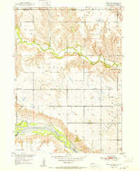
1951 Map of Butte NW
USGS Topo · Published 1951About this map
Ponca Creek carves through the landscape of the Nebraska-South Dakota border, defining the rural character of this northern Boyd County region in the early 1950s. The map captures a high density of one-room schoolhouses, illustrating a local education network that includes School No 46, School No 10, and the Ponca Valley Sch. These institutions served the dispersed farmsteads throughout Pleasant Valley and the surrounding townships. To the south, the confluence of the Keya Paha River and the Niobrara River highlights the essential water resources of the Great Plains. The intricate contour lines reveal the dramatic bluffs and drainage patterns typical of this Missouri River Basin environment, with smaller tributaries like Dizzy Creek feeding into the larger river systems that shaped the settlement and agricultural development of the era.
Find a feature on this map
17 named features on this map. Tap any name to fly to it.
Don’t see what you’re looking for? This feature index may not catch every label — zoom into the map to look around manually.
Map Details
Editions of this 1951 Butte NW Map
2 editions found
Other maps of this area

1951 · Naper
USGS Topo · 1:24,000

1951 · Butte SW
USGS Topo · 1:24,000

1951 · Dustin
USGS Topo · 1:24,000

1952 · Butte SE
USGS Topo · 1:24,000

1955 · Mitchell
USGS Topo · 1:250,000

1955 · O'Neill
USGS Topo · 1:250,000

1959 · O'Neill
USGS Topo · 1:250,000

1959 · Mitchell
USGS Topo · 1:250,000

1964 · Butte
USGS Topo · 1:24,000

1964 · St. Charles
USGS Topo · 1:24,000