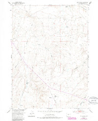
1952 Map of Butte Well
USGS Topo · Published 1985About this map
Butte Well and the remote high plains of Fremont County are captured in this mid-century survey, which reveals a landscape defined by the search for water and transportation across the basins. The importance of seasonal and subsurface water is evident through the naming of Horseshoe Creek, Muskrat Creek, and various family-named improvements such as the Mc Kenzie Windmill and Mc Kenzie Artesian Well. The presence of the Ohio Road and the Muskrat Landing Strip highlights the vital infrastructure needed for land and air travel in this part of Wyoming. Cultural landmarks like Leitch Reservoir and an Abandoned Ditch speak to the long-standing efforts to manage water for livestock or irrigation. The terrain is marked by distinctive topographic features such as Jumping-off and several drainage systems including Lame Jack Draw, Signor Draw, and Mahoney Draw.
Find a feature on this map
15 named features on this map. Tap any name to fly to it.
Don’t see what you’re looking for? This feature index may not catch every label — zoom into the map to look around manually.
Map Details
Editions of this 1952 Butte Well Map
3 editions found
Other maps of this area

1952 · Seventy-one Reservoir
USGS Topo · 1:24,000

1952 · Squaw Butte
USGS Topo · 1:24,000

1952 · Rongis Reservoir SE
USGS Topo · 1:24,000

1952 · Double Butte
USGS Topo · 1:24,000

1952 · Haybarn Hill
USGS Topo · 1:24,000

1952 · Love Ranch
USGS Topo · 1:24,000

1952 · Rongis Reservoir
USGS Topo · 1:24,000

1952 · Puddle Springs
USGS Topo · 1:24,000

1952 · Butte Well
USGS Topo · 1:24,000

1955 · Arminto
USGS Topo · 1:250,000