
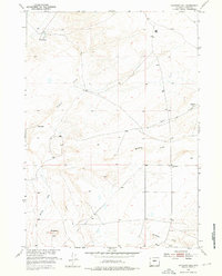
1952 Map of Haybarn Hill
USGS Topo · Published 1953About this map
Davison Ranch, Posey Ranch, and Ore Ranch anchor this mid-century look at the high plains of Fremont County, where scattered homesteads and water sources defined the livestock economy. The landscape is dominated by the seasonal drainages of Muskrat Creek and Conant Creek, which carve through the arid terrain toward the Missouri River Basin. Prominent local landmarks such as Haybarn Hill and Deadman Hill provide essential orientation points for travelers on the unpaved Scotty Clark Road. The presence of Oil Springs Creek and Horseshoe Creek in the southern reaches highlights the critical importance of water for both local wildlife and grazing stock in this part of Wyoming's interior during the early 1950s.
Find a feature on this map
10 named features on this map. Tap any name to fly to it.
Don’t see what you’re looking for? This feature index may not catch every label — zoom into the map to look around manually.
Map Details
Editions of this 1952 Haybarn Hill Map
2 editions found
Other maps of this area

1951 · Fuller Reservoir
USGS Topo · 1:24,000

1951 · Shoshoni
USGS Topo · 1:24,000

1952 · Squaw Butte NE
USGS Topo · 1:24,000

1952 · Squaw Butte
USGS Topo · 1:24,000

1952 · Ocla Draw
USGS Topo · 1:24,000

1952 · Double Butte
USGS Topo · 1:24,000

1952 · Butte Well
USGS Topo · 1:24,000

1953 · Campbell Ridge
USGS Topo · 1:24,000

1955 · Thermopolis
USGS Topo · 1:250,000

1955 · Arminto
USGS Topo · 1:250,000