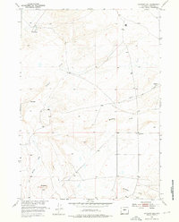
1952 Map of Haybarn Hill
USGS Topo · Published 1976About this map
Davison Ranch and Posey Ranch occupy this high-plains landscape in central Wyoming, surveyed in the early 1950s as part of the Department of the Interior’s program for the Missouri River Basin. The terrain is defined by dry drainage systems and elevated points like Haybarn Hill and Deadman Hill. A network of watercourses, including Muskrat Creek and Oil Springs Creek, shapes the local topography, while Conant Creek and Horseshoe Creek cut through the southern sections. This area reflects the mid-century ranching life of Fremont County, where scattered homesteads like Ore Ranch were linked by unimproved paths and named routes such as Scotty Road. The mapping provides a clear record of land use and property locations before significant modern development altered the remote livestock-grazing patterns of the region.
Find a feature on this map
10 named features on this map. Tap any name to fly to it.
Don’t see what you’re looking for? This feature index may not catch every label — zoom into the map to look around manually.
Map Details
Editions of this 1952 Haybarn Hill Map
2 editions found
Other maps of this area

1951 · Fuller Reservoir
USGS Topo · 1:24,000

1951 · Shoshoni
USGS Topo · 1:24,000

1952 · Squaw Butte NE
USGS Topo · 1:24,000

1952 · Squaw Butte
USGS Topo · 1:24,000

1952 · Ocla Draw
USGS Topo · 1:24,000

1952 · Double Butte
USGS Topo · 1:24,000

1952 · Haybarn Hill
USGS Topo · 1:24,000

1952 · Butte Well
USGS Topo · 1:24,000

1953 · Campbell Ridge
USGS Topo · 1:24,000

1955 · Thermopolis
USGS Topo · 1:250,000