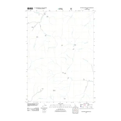
2011 Map of Buttercup Mountain
USGS Topo · Published 2011About this map
Buttercup Mountain stands as a central peak in this Idaho landscape, where a network of steep canyons and gulches defines the drainage system of Warm Springs Creek. The presence of the Buttercup Mine near Buttercup Creek points to the area's history of mineral extraction, situated in a terrain where high-elevation flats like Placer Flat and Poison Flat interrupt the complex topography. The map illustrates a watershed characterized by numerous seasonal and perennial flows, including South Fork Warm Springs Creek and the long course of Deer Creek. Names such as Cabin Gulch, Lupine Gulch, and Bear Gulch suggest a history of prospecting and wildlife, while Rough Canyon and Narrow Canyon emphasize the literal obstacles encountered by early travelers through these Sawtooth National Forest lands.
Find a feature on this map
39 named features on this map. Tap any name to fly to it.
Don’t see what you’re looking for? This feature index may not catch every label — zoom into the map to look around manually.
Map Details
Editions of this 2011 Buttercup Mountain Map
This is the sole edition of this map. No revisions or reprints were ever made.
Other maps of this area

1895 · Hailey
USGS Topo · 1:125,000

1897 · Hailey
USGS Topo · 1:125,000

1900 · Sawtooth
USGS Topo · 1:125,000

1955 · Hailey
USGS Topo · 1:250,000

1957 · Bellevue
USGS Topo · 1:62,500

1957 · Blaine
USGS Topo · 1:62,500

1959 · Hailey
USGS Topo · 1:250,000

1962 · Hailey
USGS Topo · 1:250,000

1967 · Mahoney Butte
USGS Topo · 1:24,000
1967 · Griffin Butte
USGS Topo · 1:24,000