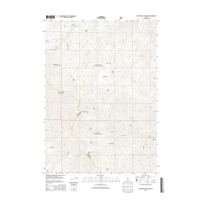
2013 Map of Buttercup Mountain
USGS Topo · Published 2013About this map
Buttercup Mtn and the surrounding Smoky Mountains anchor this 2013 high-elevation landscape along the boundary of Blaine and Camas Counties. Contained within the Sawtooth National Forest, the terrain is defined by a complex network of drainages and named gulches that suggest early mining and ranching activity. Notable features like Placer Flat and Cabin Gulch point to the area's historical prospecting and settler ties, while Poison Flat and Lupine Gulch reflect the local botanical character of the range. The map details a rugged hydrologic system where S Fork Warm Springs Cr and Deer Cr carve deep paths through the mountains. Recreational infrastructure is represented by the Deer Creek Campground along Deer Creek Rd, marking one of the few points of modern accessibility in this vast, backcountry terrain of central Idaho.
Find a feature on this map
38 named features on this map. Tap any name to fly to it.
Don’t see what you’re looking for? This feature index may not catch every label — zoom into the map to look around manually.
Map Details
Editions of this 2013 Buttercup Mountain Map
This is the sole edition of this map. No revisions or reprints were ever made.
Other maps of this area

1895 · Hailey
USGS Topo · 1:125,000

1897 · Hailey
USGS Topo · 1:125,000

1900 · Sawtooth
USGS Topo · 1:125,000

1955 · Hailey
USGS Topo · 1:250,000

1957 · Bellevue
USGS Topo · 1:62,500

1957 · Blaine
USGS Topo · 1:62,500

1959 · Hailey
USGS Topo · 1:250,000

1962 · Hailey
USGS Topo · 1:250,000

1967 · Mahoney Butte
USGS Topo · 1:24,000
1967 · Griffin Butte
USGS Topo · 1:24,000