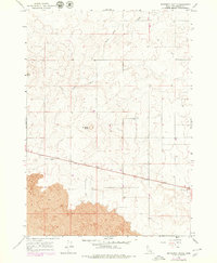
1964 Map of Butterfly Butte
USGS Topo · Published 1979About this map
Butterfly Butte and Kettle Butte dominate this Idaho landscape, rising above a vast field of basalt in the Snake River Plain. This 1964 survey, with 1979 revisions, reveals a terrain defined by volcanic activity, most notably the extensive Lava flows that cover the southwestern portion of the quadrangle. The geometry of the land is broken only by the straight line of U.S. 26, which cuts across the high desert floor toward the landmark Seventeenmile Cave. Unlike more settled regions, the map is nearly devoid of structures, instead highlighting the utility of the land through numerous scattered wells, indicating a reliance on groundwater in this arid environment. The presence of several drains further illustrates the management of water across the undulating basaltic surface between the prominent volcanic buttes.
Find a feature on this map
10 named features on this map. Tap any name to fly to it.
Don’t see what you’re looking for? This feature index may not catch every label — zoom into the map to look around manually.
Map Details
Editions of this 1964 Butterfly Butte Map
2 editions found
Other maps of this area

1948 · Woodville
USGS Topo · 1:24,000

1949 · Roberts
USGS Topo · 1:62,500

1949 · Roberts
USGS Topo · 1:24,000

1949 · Shattuck Butte
USGS Topo · 1:24,000

1950 · Shattuck Butte
USGS Topo · 1:24,000

1950 · Woodville
USGS Topo · 1:24,000

1950 · Roberts
USGS Topo · 1:24,000

1955 · Idaho Falls
USGS Topo · 1:250,000

1958 · Idaho Falls
USGS Topo · 1:250,000
1959 · Woodville
USGS Topo · 1:24,000