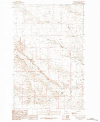
1984 Map of Button Butte
USGS Topo · Published 1984About this map
Button Butte rises as the primary landmark in this drainage-heavy landscape within Phillips County, surveyed in the late 1970s. The terrain is defined by a dense network of coulees and creeks that feed into the large Nelson Reservoir in the east. The map records the local water management and ranching infrastructure of the era, most notably the Rock Dam located along Beaver Creek. To the west, the winding path of Big Warm Creek cuts through the topography, joined by smaller systems like Nelson Coulee and White Rock Coulee. This provisional survey preserves the precise contours of the Montana breaks before modern modifications, showing a landscape where water sources and high points like the butte dictated the movement and settlement of the region.
Find a feature on this map
7 named features on this map. Tap any name to fly to it.
Don’t see what you’re looking for? This feature index may not catch every label — zoom into the map to look around manually.
Map Details
Editions of this 1984 Button Butte Map
This is the sole edition of this map. No revisions or reprints were ever made.
Other maps of this area

1953 · Havre
USGS Topo · 1:250,000

1954 · Jordan
USGS Topo · 1:250,000

1954 · Glasgow
USGS Topo · 1:250,000

1954 · Lewistown
USGS Topo · 1:250,000

1956 · Jordan
USGS Topo · 1:250,000

1957 · Glasgow
USGS Topo · 1:250,000

1957 · Havre
USGS Topo · 1:250,000

1958 · Glasgow
USGS Topo · 1:250,000

1958 · Jordan
USGS Topo · 1:250,000

1958 · Havre
USGS Topo · 1:250,000