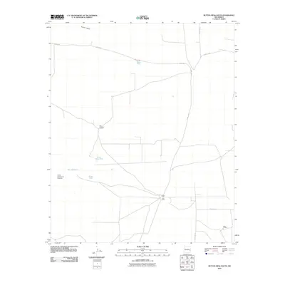
2010 Map of Button Mesa South
USGS Topo · Published 2010About this map
U Bar Ranch and Cooper Ranch anchor this corner of the High Plains, illustrating the enduring cattle-ranching layout of Lea County in the early 21st century. The landscape is defined by the practical infrastructure of water management in a semi-arid environment, marked by named water sources like White Tank and North Plains Tank. These features, alongside isolated landmarks such as High Lonesome Windmill, speak to the necessity of livestock watering across wide stretches of open range. Topographically, the area is bounded by the rise of Button Mesa and the distinctively named Punta Culebra de Cascade. A network of local roads, including Nogeezi Rd and several county routes, provide the only connective tissue through this sparsely populated ranching territory.
Find a feature on this map
15 named features on this map. Tap any name to fly to it.
Don’t see what you’re looking for? This feature index may not catch every label — zoom into the map to look around manually.
Map Details
Editions of this 2010 Button Mesa South Map
This is the sole edition of this map. No revisions or reprints were ever made.
Other maps of this area

1954 · Brownfield
USGS Topo · 1:250,000

1958 · Brownfield
USGS Topo · 1:250,000

1962 · Brownfield
USGS Topo · 1:250,000

1973 · Caprock
USGS Topo · 1:24,000

1973 · Mescalero Point NE
USGS Topo · 1:24,000
1973 · Lane Salt Lake
USGS Topo · 1:24,000

1978 · Flying M Ranch
USGS Topo · 1:24,000

1978 · Button Mesa North
USGS Topo · 1:24,000
1979 · Curlew Lake SE
USGS Topo · 1:24,000
1979 · Lone Wolf
USGS Topo · 1:24,000