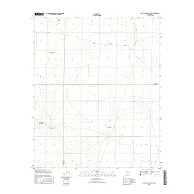
2017 Map of Button Mesa South
USGS Topo · Published 2017About this map
Button Mesa and the nearby escarpment of Punta Culebra de Cascade define this high plains landscape along the county line where Chaves and Lea counties meet. This arid stretch of New Mexico is characterized by its vital water infrastructure, with numerous catchments like White Tank, N Plains Tank, and E Sand Tank distributed across the terrain. These features, essential for ranching and livestock, highlight the importance of water management in the Llano Estacado region. The landscape is also etched with a network of local roads and cattle tracks, including Co Rd 40, Nogezzi Rd, and Ledoux Rd, which provide access to this sparse but functional ranching country. The systematic division of the land into townships such as t8s r31e and t9s r32e underscores the orderly grid of the Public Land Survey System applied to this open territory.
Find a feature on this map
18 named features on this map. Tap any name to fly to it.
Don’t see what you’re looking for? This feature index may not catch every label — zoom into the map to look around manually.
Map Details
Editions of this 2017 Button Mesa South Map
This is the sole edition of this map. No revisions or reprints were ever made.
Other maps of this area

1954 · Brownfield
USGS Topo · 1:250,000

1958 · Brownfield
USGS Topo · 1:250,000

1962 · Brownfield
USGS Topo · 1:250,000

1973 · Caprock
USGS Topo · 1:24,000

1973 · Mescalero Point NE
USGS Topo · 1:24,000
1973 · Lane Salt Lake
USGS Topo · 1:24,000

1978 · Flying M Ranch
USGS Topo · 1:24,000

1978 · Button Mesa North
USGS Topo · 1:24,000
1979 · Curlew Lake SE
USGS Topo · 1:24,000
1979 · Lone Wolf
USGS Topo · 1:24,000