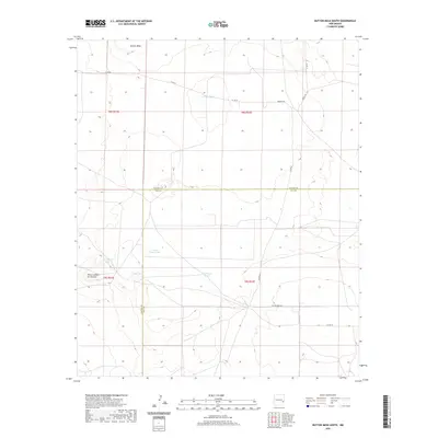
2020 Map of Button Mesa South
USGS Topo · Published 2020About this map
Button Mesa and Punta Culebra de Cascade define the high ground of this landscape along the border of Lea and Chaves counties. This arid region of New Mexico is characterized by a reliance on water storage, evidenced by the distribution of catchment points such as White Tank, North Plains Tank, and East Sand Tank. These features suggest a landscape traditionally dedicated to ranching and livestock management, where human intervention is necessary to support activity on the plains.
Find a feature on this map
19 named features on this map. Tap any name to fly to it.
Don’t see what you’re looking for? This feature index may not catch every label — zoom into the map to look around manually.
Map Details
Editions of this 2020 Button Mesa South Map
This is the sole edition of this map. No revisions or reprints were ever made.
Other maps of this area

1954 · Brownfield
USGS Topo · 1:250,000

1958 · Brownfield
USGS Topo · 1:250,000

1962 · Brownfield
USGS Topo · 1:250,000

1973 · Caprock
USGS Topo · 1:24,000

1973 · Mescalero Point NE
USGS Topo · 1:24,000
1973 · Lane Salt Lake
USGS Topo · 1:24,000

1978 · Flying M Ranch
USGS Topo · 1:24,000

1978 · Button Mesa North
USGS Topo · 1:24,000
1979 · Curlew Lake SE
USGS Topo · 1:24,000
1979 · Lone Wolf
USGS Topo · 1:24,000