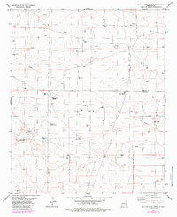
1979 Map of Button Mesa South
USGS Topo · Published 1985About this map
Button Mesa dominates the northern landscape of this High Plains survey, overlooking a vast network of resource extraction and ranching infrastructure along the boundary of Chaves and Lea counties. The development of the Flying M South Field is evident through dozens of oil and gas sites, including the Lucky Strike Well and Howell Well, connected by an extensive system of roads and a pipeline. This industrial presence exists alongside traditional cattle ranching operations centered at the Cooper Ranch. The scarcity of surface water is managed through a complex of tanks and tubs like Antelope Tub, North Plains Tank, and East Sand Tank. Notable landmarks for navigation in this open country include the High Lonesome Windmill and the topographic prominence of Punta Culebra de Cascabel in the southwest.
Find a feature on this map
30 named features on this map. Tap any name to fly to it.
Don’t see what you’re looking for? This feature index may not catch every label — zoom into the map to look around manually.
Map Details
Editions of this 1979 Button Mesa South Map
This is the sole edition of this map. No revisions or reprints were ever made.
Other maps of this area

1954 · Brownfield
USGS Topo · 1:250,000

1958 · Brownfield
USGS Topo · 1:250,000

1962 · Brownfield
USGS Topo · 1:250,000

1973 · Caprock
USGS Topo · 1:24,000

1973 · Mescalero Point NE
USGS Topo · 1:24,000
1973 · Lane Salt Lake
USGS Topo · 1:24,000

1978 · Flying M Ranch
USGS Topo · 1:24,000

1978 · Button Mesa North
USGS Topo · 1:24,000
1979 · Curlew Lake SE
USGS Topo · 1:24,000
1979 · Lone Wolf
USGS Topo · 1:24,000