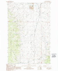
1989 Map of Buxton
USGS Topo · Published 1989About this map
Deerlodge National Forest dominates the western half of this landscape, where the Continental Divide weaves across high ridges and deep drainages. In the north, the industrial legacy of the region is evident near Silver Bow Creek, marked by a large Tailings Pond and various Prospect sites along the eastern slopes. This terrain is defined by a dense network of gulches, including Sunday Gulch, Rose Gulch, and Sawmill Gulch, which channel snowmelt toward the valleys below.
Find a feature on this map
35 named features on this map. Tap any name to fly to it.
Don’t see what you’re looking for? This feature index may not catch every label — zoom into the map to look around manually.
Map Details
Editions of this 1989 Buxton Map
This is the sole edition of this map. No revisions or reprints were ever made.
Other maps of this area

1889 · Helena
USGS Topo · 1:250,000

1893 · Helena
USGS Topo · 1:250,000

1893 · Dillon
USGS Topo · 1:250,000

1899 · Helena
USGS Topo · 1:250,000

1903 · Helena
USGS Topo · 1:250,000

1947 · Butte
USGS Topo · 1:250,000

1955 · Dillon
USGS Topo · 1:250,000

1957 · Dillon
USGS Topo · 1:250,000

1958 · Butte
USGS Topo · 1:250,000

1958 · Dillon
USGS Topo · 1:250,000