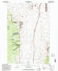
1996 Map of Buxton
USGS Topo · Published 1998About this map
The Continental Divide and the rugged topography of Deer Lodge National Forest define the character of this 1990s-era map. The landscape is a complex network of drainages and high points, including Rocky Ridge and Feeley Hill, illustrating the transition between the mountain forest and the industrial valley floor. Significant evidence of the area's mining history is visible near Silver Bow Creek, where large Tailings deposits and a Tailings Pond sit adjacent to a substation and sewage disposal ponds.
Find a feature on this map
44 named features on this map. Tap any name to fly to it.
Don’t see what you’re looking for? This feature index may not catch every label — zoom into the map to look around manually.
Map Details
Editions of this 1996 Buxton Map
This is the sole edition of this map. No revisions or reprints were ever made.
Other maps of this area

1889 · Helena
USGS Topo · 1:250,000

1893 · Helena
USGS Topo · 1:250,000

1893 · Dillon
USGS Topo · 1:250,000

1899 · Helena
USGS Topo · 1:250,000

1903 · Helena
USGS Topo · 1:250,000

1947 · Butte
USGS Topo · 1:250,000

1955 · Dillon
USGS Topo · 1:250,000

1957 · Dillon
USGS Topo · 1:250,000

1958 · Butte
USGS Topo · 1:250,000

1958 · Dillon
USGS Topo · 1:250,000