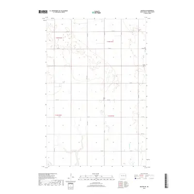
2018 Map of Buxton SW
USGS Topo · Published 2018About this map
Small rural cemeteries punctuating the vast agricultural sections of Traill County define the character of this Red River Valley landscape. Establishments like Asheim Cem, West Immanuel Cem, and Sodeberg Cem in the northeast, along with North Prairie Cem near the center, serve as important waypoints for family history and local genealogy. The terrain is notably flat, typical of the glacial lake bed, with drainage primarily following the meandering path of Buffalo Coulee and the basin of Wold Slough in the south. The township grid is strictly organized by gravel and paved routes such as Co Hwy 21, Co Rd 10, and Co Rd 19, which reflect the enduring 19th-century land survey system still in use for modern prairie farming.
Find a feature on this map
17 named features on this map. Tap any name to fly to it.
Don’t see what you’re looking for? This feature index may not catch every label — zoom into the map to look around manually.
Map Details
Editions of this 2018 Buxton SW Map
This is the sole edition of this map. No revisions or reprints were ever made.
Other maps of this area

1918 · Kelso
USGS Topo · 1:62,500

1943 · Kelso
USGS Topo · 1:62,500

1952 · Grand Forks
USGS Topo · 1:250,000

1956 · Grand Forks
USGS Topo · 1:250,000

1963 · Hillsboro
USGS Topo · 1:24,000

1966 · Grand Forks
USGS Topo · 1:250,000

1967 · Mayville South
USGS Topo · 1:24,000
1967 · Hillsboro NW
USGS Topo · 1:24,000
1970 · Mayville North
USGS Topo · 1:24,000
1971 · Buxton SW
USGS Topo · 1:24,000