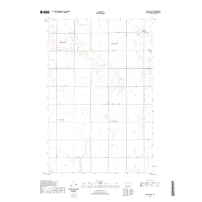
2020 Map of Buxton SW
USGS Topo · Published 2020About this map
The agrarian landscape of Traill County, North Dakota, is defined here by a precise grid of rural roads and scattered sites of genealogical significance. This 2020 edition reveals a terrain of subtle elevation changes where small water features like Buffalo Coulee and Wold Slough break the pattern of section lines. The map is particularly notable for its documentation of local burial grounds, including the Immanuel Lutheran Cem North and its companion, Immanuel Lutheran Cem West, providing a detailed record for family historians tracking roots in the Buxton area. A network of secondary routes such as Co Hwy 21 and Co Rd 19 connects these quiet landmarks, illustrating the enduring township-and-range settlement pattern of the Red River Valley's western reaches.
Find a feature on this map
18 named features on this map. Tap any name to fly to it.
Don’t see what you’re looking for? This feature index may not catch every label — zoom into the map to look around manually.
Map Details
Editions of this 2020 Buxton SW Map
This is the sole edition of this map. No revisions or reprints were ever made.
Other maps of this area

1918 · Kelso
USGS Topo · 1:62,500

1943 · Kelso
USGS Topo · 1:62,500

1952 · Grand Forks
USGS Topo · 1:250,000

1956 · Grand Forks
USGS Topo · 1:250,000

1963 · Hillsboro
USGS Topo · 1:24,000

1966 · Grand Forks
USGS Topo · 1:250,000

1967 · Mayville South
USGS Topo · 1:24,000
1967 · Hillsboro NW
USGS Topo · 1:24,000
1970 · Mayville North
USGS Topo · 1:24,000
1971 · Buxton SW
USGS Topo · 1:24,000