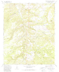
1972 Map of Buzzard Roost Mesa
USGS Topo · Published 1988About this map
The Tonto National Forest defines this high-elevation landscape, where cattle ranching and isolated habitations were supported by a complex network of springs and tanks. The map records several remote outposts, including the Flying W Ranch, Houdon Cabin, and the Spring Creek Ranch further south. These sites were connected by a series of primitive roads and trails that navigate the deep incisions of Breadpan Canyon and Bryant Canyon.
Find a feature on this map
52 named features on this map. Tap any name to fly to it.
Don’t see what you’re looking for? This feature index may not catch every label — zoom into the map to look around manually.
Map Details
Editions of this 1972 Buzzard Roost Mesa Map
2 editions found
Other maps of this area

1886 · Holbrook
USGS Topo · 1:250,000

1887 · Verde
USGS Topo · 1:250,000

1892 · Verde
USGS Topo · 1:250,000

1893 · Holbrook
USGS Topo · 1:250,000

1907 · Roosevelt
USGS Topo · 1:125,000

1909 · Four Peaks
USGS Topo · 1:125,000

1912 · Roosevelt
USGS Topo · 1:125,000

1922 · Chrysotile
USGS Topo · 1:125,000

1937 · Diamond Butte
USGS Topo · 1:48,000

1943 · Diamond Butte
USGS Topo · 1:62,500