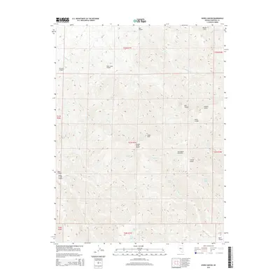
2014 Map of Byers Canyon
USGS Topo · Published 2014About this map
Healy Peak rises above a labyrinth of drainages in the Clan Alpine Mountains, anchoring a landscape defined by its network of canyons and high-desert hydrology. This 2014 survey reveals a region where water sources like Healy Spring, Granite Spring, and Eagle Spring dictate the geography of the high country. The land is carved by numerous significant cuts, including Meadow Spring Canyon, Straight Canyon, and the eponymous Byers Canyon in the southeast corner.
Find a feature on this map
32 named features on this map. Tap any name to fly to it.
Don’t see what you’re looking for? This feature index may not catch every label — zoom into the map to look around manually.
Map Details
Editions of this 2014 Byers Canyon Map
This is the sole edition of this map. No revisions or reprints were ever made.
Other maps of this area

1955 · Millett
USGS Topo · 1:250,000

1959 · Millett
USGS Topo · 1:250,000

1966 · Clan Alpine Ranch
USGS Topo · 1:62,500

1966 · Humboldt Salt Marsh
USGS Topo · 1:62,500

1966 · Shoshone Meadows
USGS Topo · 1:62,500

1966 · Edwards Creek Valley
USGS Topo · 1:62,500

1983 · Edwards Creek Valley
USGS Topo · 1:100,000

1990 · Byers Ranch
USGS Topo · 1:24,000
1990 · Mt. Augusta
USGS Topo · 1:24,000
1990 · Bernice Canyon
USGS Topo · 1:24,000