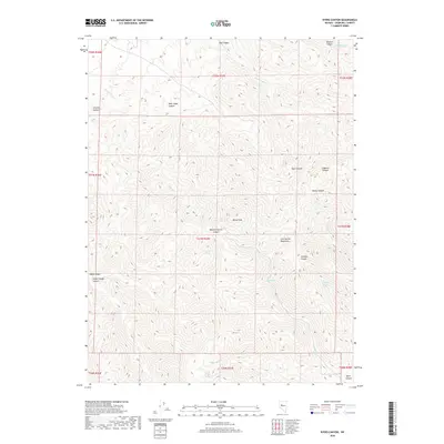
2018 Map of Byers Canyon
USGS Topo · Published 2018About this map
The Clan Alpine Mountains dominate this high-desert landscape of Churchill County, characterized by a complex network of deep drainages and isolated water sources. Centered on Healy Peak, the terrain falls away into numerous named corridors such as Bernice Canyon, Augusta Canyon, and Meadow Spring Canyon. This 2018 survey provides an essential view of the traditional range land and its vital hydrological points, including Deer Lodge Spring, Granite Spring, and Eagle Spring. These water sources, along with seasonal flows like Willow Cr and Healys Cr, have long dictated movement through this arid region. The map also records several deep incisions in the earth, such as Deep Canyon and the namesake Byers Canyon in the southeast corner, illustrating the severe erosion patterns typical of the Great Basin's interior ranges.
Find a feature on this map
33 named features on this map. Tap any name to fly to it.
Don’t see what you’re looking for? This feature index may not catch every label — zoom into the map to look around manually.
Map Details
Editions of this 2018 Byers Canyon Map
This is the sole edition of this map. No revisions or reprints were ever made.
Other maps of this area

1955 · Millett
USGS Topo · 1:250,000

1959 · Millett
USGS Topo · 1:250,000

1966 · Clan Alpine Ranch
USGS Topo · 1:62,500

1966 · Humboldt Salt Marsh
USGS Topo · 1:62,500

1966 · Shoshone Meadows
USGS Topo · 1:62,500

1966 · Edwards Creek Valley
USGS Topo · 1:62,500

1983 · Edwards Creek Valley
USGS Topo · 1:100,000

1990 · Byers Ranch
USGS Topo · 1:24,000
1990 · Mt. Augusta
USGS Topo · 1:24,000
1990 · Bernice Canyon
USGS Topo · 1:24,000