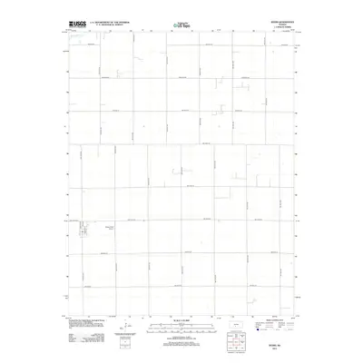
2012 Map of Byers
USGS Topo · Published 2012About this map
The agrarian landscape of Pratt County is defined by a rigorous section-line grid in this 2012 survey. The community of Byers is positioned in the southwestern portion of the map, centered on a small cluster of streets including Nation Ave, Main St, and French St. This area reflects the typical development of rural Kansas towns, where a concentrated residential and commercial core gives way to the expansive agricultural tracts that surround it. Moore Field Airport is situated just east of the primary settlement, highlighting the importance of aviation in managing the vast farm territories of the Great Plains. In the northwestern corner, the natural path of Rattlesnake Cr provides a rare deviation from the geometric road network, which consists of thoroughfares like Emerson Rd and numerous numbered avenues.
Find a feature on this map
26 named features on this map. Tap any name to fly to it.
Don’t see what you’re looking for? This feature index may not catch every label — zoom into the map to look around manually.
Map Details
Editions of this 2012 Byers Map
This is the sole edition of this map. No revisions or reprints were ever made.
Other maps of this area

1892 · Pratt
USGS Topo · 1:125,000

1894 · Pratt
USGS Topo · 1:125,000

1955 · Pratt
USGS Topo · 1:250,000

1959 · Pratt
USGS Topo · 1:250,000

1968 · Pratt
USGS Topo · 1:24,000

1968 · Cullison
USGS Topo · 1:24,000

1968 · Coats NE
USGS Topo · 1:24,000
1971 · Byers
USGS Topo · 1:24,000
1971 · Hopewell
USGS Topo · 1:24,000
1971 · Stafford SW
USGS Topo · 1:24,000