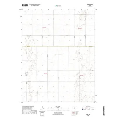
2018 Map of Byers
USGS Topo · Published 2018About this map
The small town of Byers sits at the southwestern edge of the Stafford and Pratt County line, serving as a quiet anchor for this agricultural landscape. Plotted with a simple street grid including Main St, Richter St, and Nation St, the settlement is surrounded by a vast network of section roads and low-lying wetlands. The topography is defined by subtle undulations and numerous small depressions typical of the region's prairie ecology, with Rattlesnake Cr cutting through the northwestern corner of the survey. Just east of the primary settlement, Moore Field appears as a localized landmark. This survey documents the intersection of rural infrastructure and natural drainage patterns, where the straight lines of routes like Emerson Rd and NW 90th St contrast with the irregular pockets of the Kansas plains.
Find a feature on this map
36 named features on this map. Tap any name to fly to it.
Don’t see what you’re looking for? This feature index may not catch every label — zoom into the map to look around manually.
Map Details
Editions of this 2018 Byers Map
This is the sole edition of this map. No revisions or reprints were ever made.
Other maps of this area

1892 · Pratt
USGS Topo · 1:125,000

1894 · Pratt
USGS Topo · 1:125,000

1955 · Pratt
USGS Topo · 1:250,000

1959 · Pratt
USGS Topo · 1:250,000

1968 · Pratt
USGS Topo · 1:24,000

1968 · Cullison
USGS Topo · 1:24,000

1968 · Coats NE
USGS Topo · 1:24,000
1971 · Byers
USGS Topo · 1:24,000
1971 · Hopewell
USGS Topo · 1:24,000
1971 · Stafford SW
USGS Topo · 1:24,000