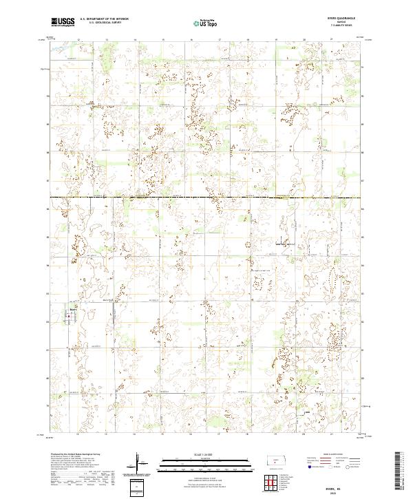
2022 Map of Byers
USGS Topo · Published 2022About this map
Byers occupies the western edge of this agricultural landscape, situated along the border of Stafford and Pratt counties. The town site is defined by its small grid of streets, including Nation St, Main St, and Richter St, surrounded by an expansive network of sectional roads and farming tracts. This 2022 survey illustrates the methodical township and range system that organized the Great Plains, with Moore Field located just north of the settlement. In the northwest corner, the subtle drainage of Rattlesnake Cr cuts through the prairie, providing a rare break in the flat, surveyed terrain. The map serves as a contemporary record of rural Kansas, documenting the persistent layout of small-town centers and the industrial-scale farming roads that connect them to the wider region.
Find a feature on this map
21 named features on this map. Tap any name to fly to it.
Don’t see what you’re looking for? This feature index may not catch every label — zoom into the map to look around manually.
Map Details
Editions of this 2022 Byers Map
This is the sole edition of this map. No revisions or reprints were ever made.
Other maps of this area

1892 · Pratt
USGS Topo · 1:125,000

1894 · Pratt
USGS Topo · 1:125,000

1955 · Pratt
USGS Topo · 1:250,000

1959 · Pratt
USGS Topo · 1:250,000

1968 · Pratt
USGS Topo · 1:24,000

1968 · Cullison
USGS Topo · 1:24,000

1968 · Coats NE
USGS Topo · 1:24,000
1971 · Byers
USGS Topo · 1:24,000
1971 · Hopewell
USGS Topo · 1:24,000
1971 · Stafford SW
USGS Topo · 1:24,000