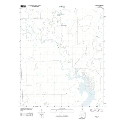
2010 Map of Byrds
USGS Topo · Published 2010About this map
Lake Brownwood dominates the southeastern corner of this landscape, its northern inlets reaching toward the community of Byrds. The shoreline is defined by the winding paths of Rough Branch and Hog Creek, while the broader valley of Pecan Bayou carves through the central terrain. This 2010 survey reflects the ranching heritage of Brown County, specifically noting the Pitcock Cattle Company Dam Number 1 and Pitcock Cattle Company Dam Number 2 on the Red River. To the northeast, Lost Creek Cemetery serves as a localized landmark for genealogists, situated near the headwaters of Lost Creek and Bledsoe Branch. The rural road network, including FM 2273 and FM 2559, connects these water-dependent ranching operations to the surrounding highlands and the northern reaches of the reservoir.
Find a feature on this map
33 named features on this map. Tap any name to fly to it.
Don’t see what you’re looking for? This feature index may not catch every label — zoom into the map to look around manually.
Map Details
Editions of this 2010 Byrds Map
This is the sole edition of this map. No revisions or reprints were ever made.
Other maps of this area

1887 · Coleman
USGS Topo · 1:125,000

1889 · Brownwood
USGS Topo · 1:125,000

1889 · Coleman
USGS Topo · 1:125,000

1894 · Eastland
USGS Topo · 1:125,000

1894 · Brownwood
USGS Topo · 1:125,000

1924 · Coleman 1-a
USGS Topo · 1:48,000

1924 · Brownwood Reservoir Site
USGS Topo · 1:48,000

1927 · Grosvenor
USGS Topo · 1:62,500

1931 · Baird
USGS Topo · 1:125,000

1932 · Baird
USGS Topo · 1:125,000