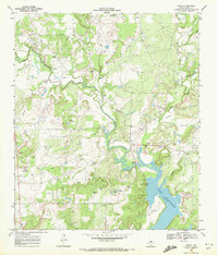
1969 Map of Byrds
USGS Topo · Published 1972About this map
Pecan Bayou and its winding tributaries dominate this Central Texas landscape, where the waters of the Cross Cut and Red Creek converge before reaching the northern reaches of Lake Brownwood. The terrain is defined by a mix of agricultural clearings and an active Oil Field, marked by numerous drill holes, oil wells, and a sprawling pipeline network. Small rural centers and family landmarks like Lewis and Byrd are scattered across the quadrangle, reflecting the area's mid-century settlement patterns.
Find a feature on this map
26 named features on this map. Tap any name to fly to it.
Don’t see what you’re looking for? This feature index may not catch every label — zoom into the map to look around manually.
Map Details
Editions of this 1969 Byrds Map
2 editions found
Other maps of this area

1887 · Coleman
USGS Topo · 1:125,000

1889 · Brownwood
USGS Topo · 1:125,000

1889 · Coleman
USGS Topo · 1:125,000

1894 · Eastland
USGS Topo · 1:125,000

1894 · Brownwood
USGS Topo · 1:125,000

1924 · Coleman 1-a
USGS Topo · 1:48,000

1924 · Brownwood Reservoir Site
USGS Topo · 1:48,000

1927 · Grosvenor
USGS Topo · 1:62,500

1931 · Baird
USGS Topo · 1:125,000

1932 · Baird
USGS Topo · 1:125,000