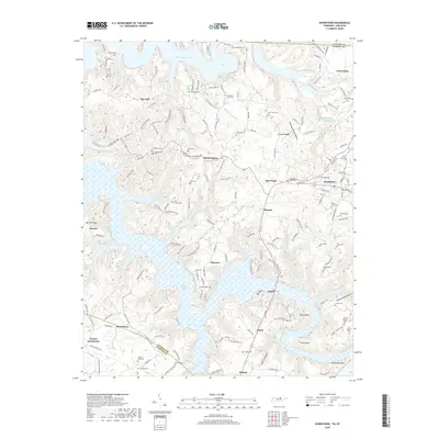
2019 Map of Byrdstown
USGS Topo · Published 2019About this map
Dale Hollow Lake and its intricate finger-like coves dominate this portion of the Highland Rim, reflecting the landscape following the mid-20th-century impoundment of the Obey River. The town of Byrdstown serves as the primary hub, surrounded by smaller traditional settlements such as Smyrna, Bloomington, and Oak Hill. The map is particularly dense with genealogical markers, documenting dozens of family burial grounds like the Amonett - Dillon Cem, Tompkins Cem, and Hatcher Hall Cem, many of which sit on high ridges overlooking the water. The terrain is defined by complex drainage systems like Wolf River and Pendergrass Cr, where deep hollows such as Blowing Springs Hollow and Horsetrough Hollow carve through the plateau. Local transport follows these ridgelines, connecting crossroads like Taylors Crossroads and Midway across the rugged Pickett Co and Overton Co line.
Find a feature on this map
166 named features on this map. Tap any name to fly to it.
Don’t see what you’re looking for? This feature index may not catch every label — zoom into the map to look around manually.
Map Details
Editions of this 2019 Byrdstown Map
This is the sole edition of this map. No revisions or reprints were ever made.
Other maps of this area

1897 · Standingstone
USGS Topo · 1:125,000

1898 · Standingstone
USGS Topo · 1:125,000

1924 · Lillydale
USGS Topo · 1:62,500

1926 · Lillydale
USGS Topo · 1:62,500

1929 · Lillydale
USGS Topo · 1:62,500

1929 · Byrdstown
USGS Topo · 1:62,500

1944 · Livingston
USGS Topo · 1:24,000

1954 · Frogue
USGS Topo · 1:24,000

1954 · Albany
USGS Topo · 1:24,000

1954 · Savage
USGS Topo · 1:24,000