
1954 Map of Frogue
USGS Topo · Published 1955About this map
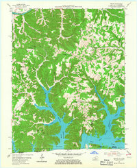
The Dale Hollow Reservoir dominates the southern landscape of this mid-century survey, its fingers reaching into deep valleys like Hendricks Creek and Fannys Creek. Located along the border of Kentucky and Tennessee, this area shows a transition from traditional river travel to modern reservoir recreation. To the north, the Cumberland River winds past Herefords and the site of Neeleys Fy, reflecting an older era of transport.
Find a feature on this map
63 named features on this map. Tap any name to fly to it.
Don’t see what you’re looking for? This feature index may not catch every label — zoom into the map to look around manually.
Map Details
Editions of this 1954 Frogue Map
2 editions found
Other maps of this area

1924 · Lillydale
USGS Topo · 1:62,500

1926 · Lillydale
USGS Topo · 1:62,500

1929 · Lillydale
USGS Topo · 1:62,500

1929 · Byrdstown
USGS Topo · 1:62,500

1953 · Waterview
USGS Topo · 1:24,000

1953 · Burkesville
USGS Topo · 1:24,000

1953 · Wolf Creek Dam
USGS Topo · 1:24,000

1954 · Blacks Ferry
USGS Topo · 1:24,000

1954 · Albany
USGS Topo · 1:24,000

1956 · Corbin
USGS Topo · 1:250,000