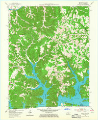
1954 Map of Frogue
USGS Topo · Published 1967About this map
Dale Hollow Reservoir dominates the southern landscape of this mid-century survey, its fingers reaching deep into the hollows and branches along the Kentucky-Tennessee border. The rising waters of the reservoir have transformed the local geography, creating features like Boys Island and flooding the lower reaches of Sulphur Creek and Fannys Creek. To the north, the Cumberland River meanders past Herefords at a sharp bend, while the uplands of Chestnut Grove Ridge and Scott Ridge maintain a traditional rural character.
Find a feature on this map
82 named features on this map. Tap any name to fly to it.
Don’t see what you’re looking for? This feature index may not catch every label — zoom into the map to look around manually.
Map Details
Editions of this 1954 Frogue Map
2 editions found
Other maps of this area

1924 · Lillydale
USGS Topo · 1:62,500

1926 · Lillydale
USGS Topo · 1:62,500

1929 · Lillydale
USGS Topo · 1:62,500

1929 · Byrdstown
USGS Topo · 1:62,500

1953 · Waterview
USGS Topo · 1:24,000

1953 · Burkesville
USGS Topo · 1:24,000

1953 · Wolf Creek Dam
USGS Topo · 1:24,000

1954 · Frogue
USGS Topo · 1:24,000

1954 · Blacks Ferry
USGS Topo · 1:24,000

1954 · Albany
USGS Topo · 1:24,000