Loading...
Loading map...1916 Map of Byron
USGS Topo · Published 1948About this map
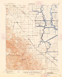
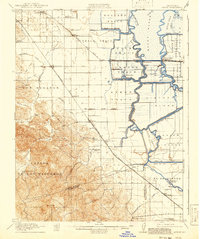
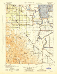
The Sacramento-San Joaquin River Delta landscape dominates this 1911 survey, showing a complex network of levees and reclaimed tracts at the height of its early agricultural development. The eastern half of the map is a maze of waterways including the Old River and Middle River, bordering massive reclamation projects like the Holland Tract, Bacon Island, and Woodward Island. These islands are dotted with numerous unnamed pumping plants, illustrating the immense engineering effort required to drain the delta for farming.
Find a feature on this map
66 named features on this map. Tap any name to fly to it.
Don’t see what you’re looking for? This feature index may not catch every label — zoom into the map to look around manually.
Map Details
Date Portrayed1916
Date Published1948
PublisherU.S. Geological Survey
Map TypeTopographic
Scale1:62,500
Physical Dimensions16.6 x 20.8 inches
Editions of this 1916 Byron Map
3 editions found

Historical Maps of Antioch Through Time
Featured Locations
Source Details
SourceU.S. Geological Survey
CopyrightPublic Domain