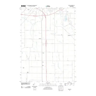
2010 Map of Byron
USGS Topo · Published 2010About this map
The agricultural landscape of south-central Wisconsin is defined by several small unincorporated communities and the headwaters of regional river systems. Hamilton and Byron serve as central nodes in this rural network, while Marblehead sits to the northeast. The topography is shaped by the presence of Devils Lake and DeNeveu Lake, with numerous waterways such as De Neveu Creek and Parsons Creek carving through the terrain. Genealogists will find several burial grounds including Bethel Cemetery, Saint Johns Cemetery, and Byron Cemetery distributed throughout the area. To the south, South Byron marks a distinct settlement near the West Branch Milwaukee River. The area maintains its rural character with features like Camp Byron and the Baier Landing Strip located west of the main thoroughfares.
Find a feature on this map
51 named features on this map. Tap any name to fly to it.
Don’t see what you’re looking for? This feature index may not catch every label — zoom into the map to look around manually.
Map Details
Editions of this 2010 Byron Map
This is the sole edition of this map. No revisions or reprints were ever made.
Other maps of this area

1910 · Fond du Lac
USGS Topo · 1:62,500

1955 · Waupun
USGS Topo · 1:62,500

1955 · Campbellsport
USGS Topo · 1:62,500

1955 · Fond Du Lac
USGS Topo · 1:62,500

1955 · Fond Du Lac
USGS Topo · 1:24,000

1956 · Rosendale
USGS Topo · 1:62,500

1957 · Madison
USGS Topo · 1:250,000

1960 · Madison
USGS Topo · 1:250,000
1974 · St. Peter
USGS Topo · 1:24,000
1974 · Campbellsport
USGS Topo · 1:24,000