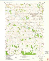
1974 Map of Campbellsport
USGS Topo · Published 1978About this map
The Campbellsport Drumlins dominate this glacial landscape, shaping a terrain of distinct ridges and low-lying wetlands at the edge of the Ice Age National Scientific Reserve. In the mid-1970s, the village of Campbellsport serves as the regional hub, situated where the Chicago and North Western railroad crosses the Milwaukee River. The river's path is marked by industrial and municipal infrastructure, including the Campbellsport Millpond and several sewage disposal sites.
Find a feature on this map
68 named features on this map. Tap any name to fly to it.
Don’t see what you’re looking for? This feature index may not catch every label — zoom into the map to look around manually.
Map Details
Editions of this 1974 Campbellsport Map
This is the sole edition of this map. No revisions or reprints were ever made.
Other maps of this area

1904 · West Bend
USGS Topo · 1:62,500

1904 · Hartford
USGS Topo · 1:62,500

1955 · Campbellsport
USGS Topo · 1:62,500

1955 · Kewaskum
USGS Topo · 1:62,500

1957 · Madison
USGS Topo · 1:250,000

1959 · West Bend
USGS Topo · 1:62,500

1959 · Hartford
USGS Topo · 1:62,500

1959 · Nenno
USGS Topo · 1:24,000

1959 · Allenton
USGS Topo · 1:24,000
1959 · West Bend
USGS Topo · 1:24,000