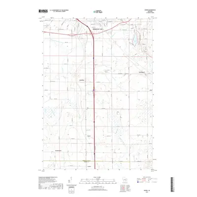
2018 Map of Byron
USGS Topo · Published 2018About this map
Fond Du Lac stands at the northern edge of this landscape, where the East Branch Fond Du Lac River and De Neveu Cr drain toward the city. The area is defined by a series of small, established settlements like Hamilton, Marblehead, and Byron, connected by a dense network of county roads. To the southeast, the headwaters of the W Br Milwaukee River begin their course, marking a subtle continental divide in the drainage patterns of the region. Local history is anchored by several burial grounds, including Saint Johns Cem, Byron Cem, and Oak Grove Cem, which serve as vital landmarks for genealogists. The topography is shaped by glacial features, most notably seen in the depressions containing Lake De Neveu and Devils Lake near the eastern margin. These water bodies, along with smaller streams like Parsons Cr and Campground Cr, illustrate the complex hydrology that influenced early settlement and agriculture in both Fond du Lac and Dodge counties.
Find a feature on this map
90 named features on this map. Tap any name to fly to it.
Don’t see what you’re looking for? This feature index may not catch every label — zoom into the map to look around manually.
Map Details
Editions of this 2018 Byron Map
This is the sole edition of this map. No revisions or reprints were ever made.
Other maps of this area

1910 · Fond du Lac
USGS Topo · 1:62,500

1955 · Waupun
USGS Topo · 1:62,500

1955 · Campbellsport
USGS Topo · 1:62,500

1955 · Fond Du Lac
USGS Topo · 1:62,500

1955 · Fond Du Lac
USGS Topo · 1:24,000

1956 · Rosendale
USGS Topo · 1:62,500

1957 · Madison
USGS Topo · 1:250,000

1960 · Madison
USGS Topo · 1:250,000
1974 · St. Peter
USGS Topo · 1:24,000
1974 · Campbellsport
USGS Topo · 1:24,000