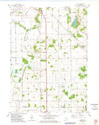
1974 Map of Byron
USGS Topo · Published 1978About this map
Extensive limestone extraction and rail transport define the landscape of the Fond du Lac and Dodge County border in the mid-1970s. The village of Marblehead is dominated by local Quarry operations and Kilns, connected to the wider region via the Chicago and North Western railroad. To the west, the village of Hamilton sits near the Hamilton Oak Grove Cem, while Byron and South Byron serve as agricultural and transit hubs along the Soo Line. The terrain is marked by a clear transition from the marshy lowlands surrounding the East Branch Fond du Lac River and Parsons Creek to the more elevated grounds of the Empire township. Educational and social centers like St Johns Sch and Camp Byron indicate a well-established community fabric, while the northern waters of Lake De Neveu and Devils Lake offer a sharp contrast to the industrial pits and gravel operations scattered across the quadrangle.
Find a feature on this map
51 named features on this map. Tap any name to fly to it.
Don’t see what you’re looking for? This feature index may not catch every label — zoom into the map to look around manually.
Map Details
Editions of this 1974 Byron Map
This is the sole edition of this map. No revisions or reprints were ever made.
Other maps of this area

1910 · Fond du Lac
USGS Topo · 1:62,500

1955 · Waupun
USGS Topo · 1:62,500

1955 · Campbellsport
USGS Topo · 1:62,500

1955 · Fond Du Lac
USGS Topo · 1:62,500

1955 · Fond Du Lac
USGS Topo · 1:24,000

1956 · Rosendale
USGS Topo · 1:62,500

1957 · Madison
USGS Topo · 1:250,000

1960 · Madison
USGS Topo · 1:250,000
1974 · St. Peter
USGS Topo · 1:24,000
1974 · Campbellsport
USGS Topo · 1:24,000