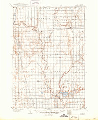
1895 Map of Byron
USGS Topo · Published 1950About this map
The James River meanders south through this late nineteenth-century Dakota landscape, serving as a central artery for a region organized into expansive townships like Frankfort and Pleasant View. This 1893 survey captures the early footprint of the Chicago and Northwestern R. R. as it cuts eastward across the plains, facilitating the growth of rail-side settlements such as Doland and Crandon. The terrain is defined by the broad prairie and the elevation of Doland Ridge, which rises above the river valley. In the southern portion of the map, the boundary between Spink Co. and Beadle Co. is established just above the waters of Byron Lake and Connors Lake. These water bodies and smaller tributaries like Turtle Creek and Timber Creek provided essential resources for the dispersed homesteads and growing towns of the era.
Find a feature on this map
53 named features on this map. Tap any name to fly to it.
Don’t see what you’re looking for? This feature index may not catch every label — zoom into the map to look around manually.
Map Details
Editions of this 1895 Byron Map
4 editions found
Other maps of this area

1894 · Conde
USGS Topo · 1:62,500

1895 · Byron
USGS Topo · 1:125,000

1895 · Aberdeen
USGS Topo · 1:125,000

1898 · Huron
USGS Topo · 1:125,000

1899 · Northville
USGS Topo · 1:125,000

1899 · Redfield
USGS Topo · 1:125,000

1899 · De Smet
USGS Topo · 1:125,000

1950 · Wessington NE
USGS Topo · 1:24,000

1953 · Frankfort
USGS Topo · 1:24,000

1953 · Redfield North
USGS Topo · 1:24,000