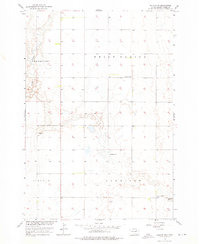
1956 Map of Doland SW
USGS Topo · Published 1976About this map
Belle Plaine and Frankfort townships define the northern reaches of this Spink County landscape, mapped as part of the mid-century effort to develop the Missouri River Basin. The terrain is largely defined by the meandering course of Timber Creek in the northwest and intermittent water features like Spring and a Flowing Well. This survey captures a rural prairie infrastructure focused on community hubs, featuring the Ebenezer Cem and local country schools. The placement of Lawrence Sch in the north and Happy Hollow Sch in the southeast suggests the distributed nature of early educational districts across Harrison and Lincoln townships. This 1956 survey provides a record of the section-line road grid and rural homestead placements before later agricultural consolidation altered the local settlement patterns.
Find a feature on this map
10 named features on this map. Tap any name to fly to it.
Don’t see what you’re looking for? This feature index may not catch every label — zoom into the map to look around manually.
Map Details
Editions of this 1956 Doland SW Map
2 editions found
Other maps of this area

1895 · Byron
USGS Topo · 1:125,000

1953 · Frankfort
USGS Topo · 1:24,000

1953 · Huron
USGS Topo · 1:250,000

1954 · Huron
USGS Topo · 1:250,000

1956 · Lake Byron NW
USGS Topo · 1:24,000

1956 · Glendale Colony
USGS Topo · 1:24,000

1956 · Spink Colony
USGS Topo · 1:24,000

1956 · Doland SW
USGS Topo · 1:24,000
1971 · Doland NW
USGS Topo · 1:24,000
1971 · Doland
USGS Topo · 1:24,000
Featured Places
- Frankfort Township, SD
- Harrison Township, SD
- Lincoln Township, SD
- Belle Plaine Township, SD
- Spink County, SD