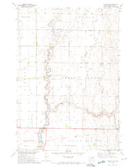
1971 Map of Doland NW
USGS Topo · Published 1974About this map
Timber Creek meanders through the heart of this Spink County landscape, shaping the drainage patterns and local topography of the eastern Dakotas in the early 1970s. The map illustrates a strictly organized agricultural grid, with township sections defining the boundaries of Clifton, Sumner, Harmony, Prairie Center, Frankfort, and Belle Plaine. An interesting historical element is the Old Railroad Grade running through the southern sections, marking the path of former transit infrastructure that once supported the transport of grain and livestock from these prairie townships. Aside from the occasional Well, the map is dominated by open land and rural section lines, offering a clear view of the region's late-century rural character and environmental features before further modern consolidation.
Find a feature on this map
9 named features on this map. Tap any name to fly to it.
Don’t see what you’re looking for? This feature index may not catch every label — zoom into the map to look around manually.
Map Details
Editions of this 1971 Doland NW Map
This is the sole edition of this map. No revisions or reprints were ever made.
Other maps of this area

1894 · Conde
USGS Topo · 1:62,500

1895 · Byron
USGS Topo · 1:125,000

1895 · Aberdeen
USGS Topo · 1:125,000

1953 · Frankfort
USGS Topo · 1:24,000

1953 · Huron
USGS Topo · 1:250,000

1954 · Aberdeen
USGS Topo · 1:250,000

1954 · Huron
USGS Topo · 1:250,000

1956 · Aberdeen
USGS Topo · 1:250,000

1956 · Glendale Colony
USGS Topo · 1:24,000

1956 · Doland SW
USGS Topo · 1:24,000
Featured Places
- Clifton Township, SD
- Prairie Center Township, SD
- Camrose Hutterite Colony, SD
- Sumner Township, SD
- Frankfort Township, SD