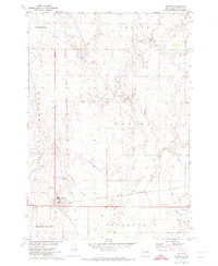
1971 Map of Doland
USGS Topo · Published 1974About this map
Doland serves as the central hub of this agricultural landscape in Spink County, organized by a rigid grid of sections and townships including Prairie Center and Belle Plaine. The town's economy and layout are defined by the Chicago and North Western railroad, which cuts through the southern portion of the settlement. To the west, an Old Railroad Grade indicates a shift in the local transportation network, while a Landing Strip to the east reflects modern mid-century infrastructure. Small-scale industrial activity is evidenced by scattered Gravel Pits, and local history is anchored at the Doland Cem just outside the main town site. The map captures the quiet transition of a Great Plains farming community as it appeared in the early 1970s, including essential municipal features like the Sewage Disposal Ponds.
Find a feature on this map
15 named features on this map. Tap any name to fly to it.
Don’t see what you’re looking for? This feature index may not catch every label — zoom into the map to look around manually.
Map Details
Editions of this 1971 Doland Map
This is the sole edition of this map. No revisions or reprints were ever made.
Other maps of this area

1894 · Conde
USGS Topo · 1:62,500

1895 · Byron
USGS Topo · 1:125,000

1895 · Aberdeen
USGS Topo · 1:125,000

1953 · Milbank
USGS Topo · 1:250,000

1953 · Huron
USGS Topo · 1:250,000

1953 · Watertown
USGS Topo · 1:250,000

1954 · Aberdeen
USGS Topo · 1:250,000

1954 · Huron
USGS Topo · 1:250,000

1956 · Aberdeen
USGS Topo · 1:250,000

1956 · Doland SW
USGS Topo · 1:24,000