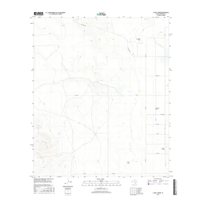
2016 Map of C And L Draw
USGS Topo · Published 2016About this map
Cornudas Draw and Washburn Draw cut through the arid terrain of Hudspeth County, illustrating the vital role of ephemeral drainage systems in this part of West Texas. This 2016 survey shows a landscape organized by extensive ranching infrastructure, where water management is centralized around features like Jones Tank and Lake Tank. The grid of local roads, such as Jones Ranch Rd, Lynch Rd, and Guitar Rd, suggests a territory of large holdings and rural industry. The presence of Farm 2249 indicates a primary transportation artery through the region, connecting remote ranch entries and providing access to the namesake C and L Draw that meanders across the southern portion of the quadrangle. For researchers of Texas land use, the map provides a clear look at contemporary desert water conservation and property access points.
Find a feature on this map
16 named features on this map. Tap any name to fly to it.
Don’t see what you’re looking for? This feature index may not catch every label — zoom into the map to look around manually.
Map Details
Editions of this 2016 C And L Draw Map
This is the sole edition of this map. No revisions or reprints were ever made.
Other maps of this area

1951 · Dell City
USGS Topo · 1:62,500

1954 · Carlsbad
USGS Topo · 1:250,000

1954 · Van Horn
USGS Topo · 1:250,000

1955 · Cerro Diablo
USGS Topo · 1:62,500

1958 · Van Horn
USGS Topo · 1:250,000

1958 · Carlsbad
USGS Topo · 1:250,000
1969 · Culp Draw
USGS Topo · 1:24,000
1970 · Shiloh Hills SE
USGS Topo · 1:24,000
1970 · Mc Veigh Hills
USGS Topo · 1:24,000

1979 · Crow Flats
USGS Topo · 1:100,000