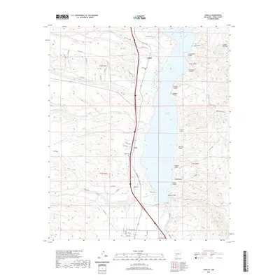
2020 Map of Caballo
USGS Topo · Published 2020About this map
Caballo Reservoir dominates the center of this Sierra County landscape, where the waters of the Rio Grande are held against the western slopes of the Caballo Mountains. The settlement of Caballo and the nearby community of Oasis serve as focal points for local habitation along the western shore, supported by a network of ranch roads like Smith Ranch Rd and Carriage Dr. To the south, the Rincon Valley opens up, while the northern and eastern portions of the map are defined by a complex system of drainage, including Seco Creek, Ash Canyon, and Bat Cave Canyon. Genealogists may find interest in the Caballo Cem, located near the reservoir's edge. The terrain transitions from the high peaks of the mountains down through various arroyos, such as Greyback Arroyo and Nordstrom Arroyo, which channel seasonal runoff toward the river basin.
Find a feature on this map
61 named features on this map. Tap any name to fly to it.
Don’t see what you’re looking for? This feature index may not catch every label — zoom into the map to look around manually.
Map Details
Editions of this 2020 Caballo Map
This is the sole edition of this map. No revisions or reprints were ever made.
Other maps of this area

1954 · Tularosa
USGS Topo · 1:250,000

1955 · Las Cruces
USGS Topo · 1:250,000

1958 · Las Cruces
USGS Topo · 1:250,000

1958 · Tularosa
USGS Topo · 1:250,000

1959 · Engle
USGS Topo · 1:62,500

1959 · Upham
USGS Topo · 1:62,500

1961 · Skute Stone Arroyo
USGS Topo · 1:24,000

1961 · Saladone Tank
USGS Topo · 1:24,000

1961 · Caballo
USGS Topo · 1:24,000

1961 · Clark Spring Canyon
USGS Topo · 1:24,000