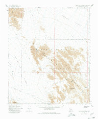
1965 Map of Cabeza Prieta Peak
USGS Topo · Published 1980About this map
The Cabeza Prieta Mountains anchor this arid landscape of the Sonoran Desert, where remote water sources and historical trails define the territory. In this mid-century survey, the intersection of military and conservation land is evident through the overlapping boundaries of the Luke Air Force Range and the Cabeza Prieta Game Range. Evidence of human passage and hardship is etched into the terrain along the Camino Del Diablo, a path notorious for its difficulty, marked here by a lone grave and the elusive Coyote Water. The mapping of reliable catchments such as Cabeza Prieta Tanks and Halfway Tank underscores the critical importance of water for those navigating the Lechuguilla Desert. Mining history is represented by the McMillan Mine near the Copper Mountains, while peaks like Buck Peak and Tordillo Mtn provide prominent vertical relief across the desert floor.
Find a feature on this map
29 named features on this map. Tap any name to fly to it.
Don’t see what you’re looking for? This feature index may not catch every label — zoom into the map to look around manually.
Map Details
Editions of this 1965 Cabeza Prieta Peak Map
2 editions found

Other maps of this area

1926 · Wellton
USGS Topo · 1:62,500

1926 · Mohawk
USGS Topo · 1:62,500

1927 · Kim
USGS Topo · 1:62,500

1928 · Mohawk
USGS Topo · 1:62,500

1929 · Wellton
USGS Topo · 1:62,500

1931 · Kim
USGS Topo · 1:62,500

1942 · Yuma
USGS Topo · 1:250,000

1953 · Ajo
USGS Topo · 1:250,000

1954 · El Centro
USGS Topo · 1:250,000

1955 · El Centro
USGS Topo · 1:250,000