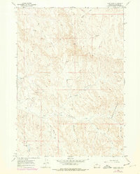
1966 Map of Cabin Fork
USGS Topo · Published 1978About this map
The erosional badlands of The Honeycombs dominate the southeastern portion of this Washakie County landscape, where the terrain is deeply dissected by ephemeral drainages and draws. During the mid-1960s, this area functioned primarily as rangeland and a site for resource extraction, evidenced by several Oil Wells, a Flowing Well, and the industrial Macaroni Pit. Water management in this arid environment is central to the map's layout, showing small-scale catchments like the Denver Jake Dam and Lyman Reservoir No 1 nestled among the hills.
Find a feature on this map
19 named features on this map. Tap any name to fly to it.
Don’t see what you’re looking for? This feature index may not catch every label — zoom into the map to look around manually.
Map Details
Editions of this 1966 Cabin Fork Map
2 editions found
Other maps of this area

1955 · Sheridan
USGS Topo · 1:250,000

1955 · Arminto
USGS Topo · 1:250,000

1958 · Sheridan
USGS Topo · 1:250,000

1958 · Arminto
USGS Topo · 1:250,000

1962 · Sheridan
USGS Topo · 1:250,000

1962 · Arminto
USGS Topo · 1:250,000

1966 · Deadline Draw
USGS Topo · 1:24,000

1966 · Cabin Fork
USGS Topo · 1:24,000

1966 · Wagon Prong
USGS Topo · 1:24,000
1966 · Henry Draw
USGS Topo · 1:24,000