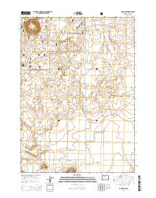
2014 Map of Cabin Lake
USGS Topo · Published 2014About this map
Deschutes National Forest encompasses the northern half of this landscape, where the volcanic geology of Lake County is evident in prominent landmarks. The volcanic history is anchored by Flat Top in the northwest and Reub Long Butte to the south, while Ft Rock stands near the edge of the expansive Fort Rock Valley. Water is a scarce and vital resource in this high desert environment, represented by the namesake Cabin Lake near the forest boundary. The map documents a network of forest and access roads, including Cabin Lake Rd and various Bureau of Land Management routes like BLM 6149-80, which served the local ranching and forestry needs of the early 21st century. This survey provides a clear view of the transition from protected forest lands to the open basins of the high desert floor.
Find a feature on this map
18 named features on this map. Tap any name to fly to it.
Don’t see what you’re looking for? This feature index may not catch every label — zoom into the map to look around manually.
Map Details
Editions of this 2014 Cabin Lake Map
This is the sole edition of this map. No revisions or reprints were ever made.
Other maps of this area

1931 · Newberry Crater
USGS Topo · 1:125,000

1935 · Newberry Crater
USGS Topo · 1:125,000

1955 · Crescent
USGS Topo · 1:250,000

1957 · Crescent
USGS Topo · 1:250,000

1958 · Crescent
USGS Topo · 1:250,000

1970 · Crescent
USGS Topo · 1:250,000

1979 · Crescent
USGS Topo · 1:100,000

1981 · Cougar Mtn
USGS Topo · 1:24,000
1981 · Fort Rock
USGS Topo · 1:24,000
1981 · Cabin Lake
USGS Topo · 1:24,000