
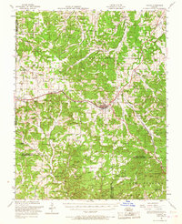
1951 Map of Cabool
USGS Topo · Published 1958About this map
The St Louis-San Francisco RR serves as the primary corridor through this portion of the Ozarks, connecting the regional hubs of Cabool and Mountain Grove. The landscape is a network of small, rural communities and agricultural clearings characterized by a high density of neighborhood institutions. Numerous country schools and churches, such as Hamilton Creek Church and Brushy Knob School, anchor the remote settlements, while several others like the Excelsior School were already noted as abandoned by the early 1950s. To the south, the terrain transitions into the protected timberlands of the Mark Twain National Forest, where the Sterling Lookout Tower stands near the village of Sterling. Geologic features like Onyx Cave and the headwaters of the Big Piney River highlight the area's karst topography, while the small post office at Dunn and various family cemeteries provide vital markers for local genealogical research.
Find a feature on this map
74 named features on this map. Tap any name to fly to it.
Don’t see what you’re looking for? This feature index may not catch every label — zoom into the map to look around manually.
Map Details
Editions of this 1951 Cabool Map
2 editions found
Other maps of this area

1931 · Manes
USGS Topo · 1:48,000

1937 · Buckhart
USGS Topo · 1:48,000

1939 · Topaz
USGS Topo · 1:62,500

1941 · Topaz
USGS Topo · 1:62,500

1941 · Manes
USGS Topo · 1:62,500

1941 · Bado
USGS Topo · 1:62,500

1943 · Manes
USGS Topo · 1:62,500

1943 · Bado
USGS Topo · 1:62,500

1943 · Buckhart
USGS Topo · 1:62,500

1945 · Harrison
USGS Topo · 1:250,000